I ventured out along the Tissington Trail today. I parked at Alsop en la Dale and headed south towards Ashbourne to meet up with Peak Park Trails rangers who I knew were working in the Mapleton car park area. It is a section of Peakland trail that I haven't cycled along for ages and despite the grey, heavy clouds it made me think again how lucky we are to live where we do with all of this lovely countryside right on our doorstep. On the way down the trail was pretty much empty, except for the odd dog walker and I was able to use the gentle downward slope to travel along quite quickly. It was wet and amazingly quite busy on the way back!
Peak Park Authority now has two dedicated trails rangers who look after Tissington, High Peak, Monsal and Thornhill trails. The purpose of my visit to meet up with Dave and Emily was to see how we might be able to assist them with some track maintenance in 2020. Given our training with Marion Farrell and her Groundwork team I feel as though we have well and truly demonstrated our capability with bow saw and loppers.
It was very soon evident that significant trackside scrub clearing and tree cutting has been undertaken, especially south of the Tissington car park. Regular piles of thin tree boughs are dotted along the route to provide natural habitat that will encourage a greater diversity of fauna to live close to the trail. As I closed in on where the rangers had obviously been working the extent of their activity became even more colossal with much larger trees felled and large sections of trunk awaiting movement to firewood providers, I presume.
As Dave and Emily had been held up getting to the site I decided to go and treat myself to a coffee and cake at the wonderful "stickyfingers" cafe in Ashbourne. I enjoyed a coffee and lovely mince pie, even though I had hardly earned the latter. When I finally caught up with the rangers they told me;
The planned resurfacing of a large section of Tissington trail, north of Ashbourne is due to take place in February 2020 but due to a delay in getting a bridge certfified the whole job may now have to be deferred until February 2021.
The use of volunteers by Peak Park Authority is becoming more difficult without a lot of accompanying supervision. Dave and Emily are concerned that the limitations on their supervisory resource will prevent them from using a lot of high number volunteer groups. There will be some opportunities and he will certainly think about how he might be able to use the services that we are offering.
As an alternative, what they are looking to do is to appoint a smaller number of trails volunteers who will be formally recruited, undergo specific training and then induction sessions before they are let out to work in a much less supervised way, in pairs. Application for these posts is likely to start in March 2020.
Dave is happy to accede to our request for additional signage at Parsley Hay. He will let us have some dates in 2020 when he can be there to discuss the positioning of signage and planting of appropriate new posts (he will supply), if necessary.
The question of signing NCR 548 out of Hartington is not something that is of any concern to him, nor is the condition of NCR 548 from its start point to Dale end, Biggin. He is putting me in touch with the Ranger whose responsibility that trail is and I will take the matter up with them.
Dave is appreciative of our links with them (I think) but I am not sure that they will generate any great level of request for help from us, certainly not on a regular basis.
To note: the signage along the trail, together with signpositing to NCR 547 from Tissington all seemed perfectly adequate and in tact.
Friday, 20 December 2019
Friday, 6 December 2019
Route 680 - Temporary link section
You are all aware that I have been actively working with Derbyshire Disctrict Council over the last 18 months to try and find temporary alternative routes for the (2) missing links in the White Peak Loop.
It has proved difficult to identify suitable temporary alternative routes for missing sections of the White Peak Loop around Buxton which can be promoted for leisure and family cycling, due to the busy nature of some roads which are used by a considerable number of heavy goods vehicles. The missing section between Blackwell Mill/ Millers Dale and Buxton is therefore likely to remain "missing" for the forseeable future. The recruitment of a replacement DCC project manager has been stalled several times and whilst we came close in the summer to getting somebody in the post, the offer was withdrawn at the 11th hour. Without a project manager to lead the work necessary it is unlikely there will be any substantial progress.
However, as a result of our regular discussions with DCC, funding has been secured to improve the condition of an existing bridleway which runs between Church Lane, Rowsley and Coombs Road, Bakewell as an interim measure to complete that as a temporary link. A scheme is currently being drawn up to carry out drainage work and surface repairs. It is certainly not an ideal option due to the severity of inclines at either end of the link. However, it is certainly better than having to use the A6 and it provides some absolutely fantastic views of the lower Wye and Derwent valleys. DCC are looking at the practicalities of a cycle crossing point on the A6 in Rowsley, next to the Peacock hotel. Hopefully in 2020 we will be able to sign the route officially as a temporary alternative part of NCR680.
Whilst that is all very good, positive news, the rumours are getting stronger about the reactivation of the Monsal trail as a working railway. All major political parties recognise the need to improve the rail infrastructure and this includes opening up abandoned rail lines, even if they are being put to very good use in alternative ways. Whilst the Peak Park Authority has pledged that any development could only take place if an equally suitable alternative to the Monsal Trail (NCR680) is found and developed, we might question whether even they have the strength and resilience to resist the onslaught of political and commercial pressures seeking compulsory purchase orders? If anything is likely to happen it is probable that we will see strong signs during 2020. Watch this space!
Supporting Groundwork with Track Maintenance
Once again there is a complete lack of photos to illustrate the full extent of our activities at last Monday's work day. My fault entirely, sorry for that failing!!
Anyway, a really enthusiastic bunch of White Peak Sustrans Rangers rather dominated the numbers of other regular volunteers of the Groundwork team, led by Marion Farrell. As well as David and Catherine the group also included David S, Brian and our latest recruit Jenni Ebbrell from Ashbourne (plus me). In addition we had two prospective recruits from Warslow and we hope to welcome John, Ian and possibly Doug too into our ranger numbers early in the New Year.
The weather was fantastic but after a heavy frost those tasked with removing leaves off the boardwalk section of track just south of Rowsley found that big clumps of wet vegetation were well and truly frozen to the planks. It was very hard work to get them off but by the end of the session much progress had been made and the cycle track pretty well clear of leaves. It is good to see that DCC has substantially replaced the broken planks, but how long it will be before others become damaged, we'll have to wait and see.
Individually, and in small groups, we worked closely with other members of the assembled team and found that a number of them also had a keen interest in cycling. John and Caroline from Cressbrook are particularly keen to think about becoming Sustrans rangers and so we were able to carry out some informal recruitment activity as we sawed and lopped our way along the verges of NCR680. This was a section of track we have spent quite a lot of time working on earlier in the year but Marion certainly feels as though it has a lot of interesting wildlife and fauna habitats that she wants us to develop. It was wonderful to see so many people (cyclists and walkers) using the trail
Further sessions will be required in the New Year. Monday 3 February has been proposed.
Thanks to all for a pretty intense morning of quite heavy work, but the bright sun, blue skies and convivial spirit (not to mention double helping of chocolate biscuits) all made it into a very enjoyable experience.
David and Catherine did go onto look again at the possibility of an alternative route at the start of NCR548 near Hartington. Unfortunately it is too complex a problem for a ready solution and so we will defer that task until next year. Thanks to them both for diverting round to look at the issue.
Friday, 18 October 2019
Venturing into pastures new - October work day
ON another beautifully sunny "work" day we ventured onto part of the Sustrans network that we all know least well; a stretch of route 68 leading north out of Buxton up towards Whaley Bridge and Chapel en le Frith.
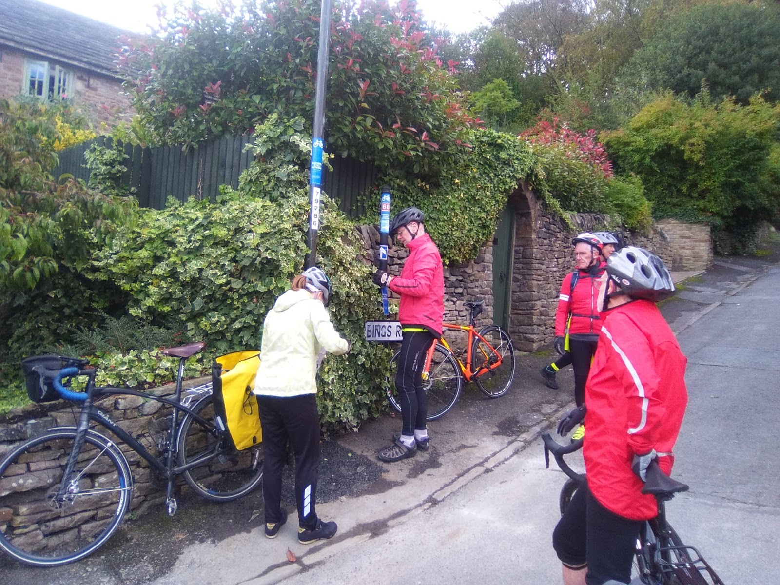
The White Peak Ranger group has responsibility for the section of route 68, which leads out of Buxton along the main Manchester Road for a couple of kilometres, before it veers away from the A5004 on a much quieter road towards Combs Moss. At this point our group hands-over responsibility for the route to Joan Bennet who looks after the next section single handedly.
Myself, the Rookes, David Sharpe and Brian Raine met up with our newest recruit Naomi McFadyen at Buxton station full of enthusiasm for a ride into parts of the Sustrans network that we are all quite unfamiliar with. Or were we? It was most gratifying to see that the extra signs we put in place earlier in the year to link the station concourse on to route 68 were still all in place. We still think that they should help people get to/ from the station from route 68 quit ereadily and so we made no further adjustments. I wonder how many people have used them and thought how helpful they are?
With no more ado we set off up the hill out of Buxton keeping well into the kerb for safety from the traffic using the same road. This is not the best section of cycle route in the country. There is no cycle track marked on the road and although the flow of traffic was not really heavy it is a slow climb out of the town through a built up area. We did wonder whether there may be some back roads behind the station which might make the exit/ approach from the station more pleasant, but decided to leave that matter for another day.
We added a few more signs to lamposts as confirmation to users of the route that they were still travelling in the correct direction. Otherwise the signage put in place about 3 years ago all seemed to be fine and only needed replacing where the sun and rain had weathered the existing signs so badly they could hardly be seen.
The point at which our responsibilities are handed over to Joan is on a dangerous bend in the A5004, but it is well signed and I guess there is a verge that cyclists can pull onto if traffic is exceptionally heavy. Unfortunately Joan was unable to ride with us on this day but she had said she was happy for us to check the route up to Whaley Bridge, if we had time.
This little lane that we now found ourselves on was new territory for me, but it was still heading north in an upwardly direction. After a short while the tarmac comes to a very sudden end and, as on our September ride, we once again found ourselves on a very rough track that many Sustrans users would find difficult to cycle on. Maybe we can try to find somebody who can "sponsor" a few lorry loads of gravel that would improve the surface enormously? Having survived the worst of it the track it levelled off a bit before deteriorating alarmingly once again to bring us down the side of the hill behind the White Hall centre. There are no alternatives for this "rough" section but maybe we need to go back and put some "rough track" stickers at either end?
Whilst these poor surface sections take a while to navigate safely they are not especially long in length. Once past them the route returns to a tarmac surface along the delightful Old Road and Long Lane before a steep drop down into Whaley Bridge. Once again, only minimal work necessary to the existing signage.
It was only as we came into the town that Naomi let on that she had lived in Whaley Bridge for many years and knew it really well. Just below where she used to live we had a major discussion about the need for siting of additional signs where the route takes a sharp deviation away from the town. It was only when David (S) located a "stray" drainwater pipe and returned it to its correct position that it all became clear as to what was required!
With Naomi's inside knowledge we enjoyed a cup of tea in a lovely cafe (thank you David) before settling to our sandwiches overlooking the canal basin. Although the sun was shining it was very autumnal sitting by the water and we all foolishly said that what we needed to warm us up was a hill!. Well , we certainly had them on the return route back to Buxton via the lovely Fernilee reservoir. We had two really monster hills, both of which went on for what seemed like endless mile after mile. Brian of course coped with them very comfortably on his e-bike. The rest of us took them more slowly. Despite the hills this made a wonderful circuit and left us with just a downhill ride along the A5004 back to our starting point at the station.
Well done everyone, another really useful day of route checking in an area that is at the extremity of our region.

Friday, 13 September 2019
September work day
Not a single picture taken during this work day! How remiss!
However, the lack of photographic evidence certainly does not detract from what we achieved. We started at Hartington and then used routes 548, 68 and 549 to complete a lovely loop through parts of the White Peak area and Dovedale. Although much of our circuit was on routes we have checked for quality and signage within the last 12 months, it was amazing just how much we found to deal with.
David (R), Catherine, David (S), myself and Brian Raine (our newest recruit) set off up the hill out of Hartington to join the start of NCR 548 (DCC are going to consider a new sign in Hartington directing riders towards 548). Brian was able to set a strong pace on his very fine looking electric bike, but was slowed down when we turned onto 548 itself. The quality of this track has deteriorated considerably due to the heavy rains, which have created some deep gullies and a lot of loose stone. I have reported the condition to both DCC (adopted highway) and Peak Rangers but not sure how highly either will prioritise it. We are also looking at the possibility of offering an alternative on-road alternative with Tom (I have requested signage from Alexa). The descent into Dale End is just as bad and caused bodily damage to one of our group!
The difficult start to the day required strong leadership and so we promptly adjourned to the delights of Biggin Hall for a very welcome coffee break. This sort of decadence is not part of our usual itinerary, but I think it could easily become so.
Refreshed by coffe and a cleaning of cycling wounds we raced on up to, and along NCR 68 to Parsley Hay. An obvious lack of signage here was clearly overlooked when we visited last year but Dave Watts (Peak Park ranger) has agreed to help make some provision to remedy the position.
Then onto Hurdlow where we reviewed the signage indicating alternative routes. This has become very faded and in need of replacement. I have subsequently requested new signage from Alexa using a form of words that will hopefully inform riders about why there are alternative routes at this point (rough track at end of High Peak Trail). A few additional signs at the end of the High Peak trail have hopefully clarified where route 68 goes to and we then returned to Hurdlow using the alternative, on-road section.
By now the effect of coffee was wearing out and lunch was well overdue. Some of the team had read the work day instructions carefully and bought sandwiches with them, as requested. I had to adjourn to the nearby Royal Oak for a rather expensive take-away which I was then able to enjoy with the others at a nearby picnic spot.
Suitably refreshed, if not somewhat chilled we cycled to the start of NCR549 and followed this lovely road all the way down to Pilsbury and then along side the river Dove in the valley bottom. It is such a delightful route back into Hartington.
Brian left us at this point but the rest of us retraced our earlier route back up the hill, but only as far as the turn off onto NCR 549, which we then followed down into Beresford Dale without incident. David and Catherine have previously reported repeated acts of sign vandalism in this area and so we were delighted to find that all of the signs they had replaced recently were still in tact. I have reported to Peak Park the possibility of confusion for walkers who follow cycling signs for Hartington at this point.
So, David and CAtherine split off at Hulme End to ride home, whilst David (S) and I cycled along the main (but quiet) road back into Hartinton and thereby end another very productive day. Thanks to all.
Sunday, 14 July 2019
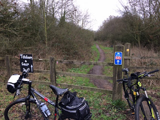
New link finally created in the Hope Valley
Our latest work day saw a small number of the group out in the Hope Valley with a very full work load for the day. We last visited NCR 6 in May 2018 and although we did a lot of re-signing on that day there was still much to do on this visit. David & Catherine and myself parked up at Hope Station and immediately started to put up new signage to direct cyclists from the station towards NCR6.
Last year we did not cycle from Hope to Castletong along NCR6 and so quite a lot of sign replacement had to be undertaken where the old signs had become very faded. Part of the day's tasks was also to address issues identified on the Earthlight map as a result of Sustran's recent route audit check. The section from Hope to Castleton had aparticularly high incidence of issues and it took us quite a long time to identify the point on the ground where improvements had to be made. Eventually we got to the current end point of NCR6, which is in the centre of Castleton itself and we duly put up a red sign advising that no further signing beyond this point was available. One day they will perhaps complete a route over Wynatts and link up with NCR6 on the other side of the Pennines where it already starts its onward journey up to the Lake District.
With our stocks of basic directional signs, as well as red NCR 6 stickers much depleted we headed back to Hope and the point at which the route turns up towards Aston. More stoppages for audit issues but eventually we arrived at Thornhill and the junction with teh Thornhill Trail. This has been a particularly difficult place to sign as somebody keeps removing or defacing signage we have put there previously. Some of the signs (but thankfully not all) we put at this point last year have been removed and had to be replaced. We also added extra signs showing onward distances from this point, as well as new signs offering cyclists the opportunity to use teh Thornhill Trail to access Bamford station (more of which later).

We found a lovely picnic spot overlooking Ladybower reservoir and ate our sandwiches as we rested after a fairly full-on morning of activity. After lunch we found that more work with signage was required that we had expected in terms of getting cyclists up to and off the track across the dam wall. We will need to monitor this signage closely as I am sure we ensured it was all in place last year.
Having sorted out the dam wall we returned to the head of teh Thornhill Trail and were relieved to find that signage placed there before lunch was still there. The signage removers are not as efficient as us!
In May 2018 we started our efforts to get all the necessary permissions to use teh Thornhill Trail and Water LAne, BAmford to create a permitted link to Bamford station. It has taken us over a year to get the permissions (Peak Park, Quakers, Local businesses, DCC and Parish Council) and special signage. Armed with signs we cycled along the lovely wooded trail (old railway line used for constructing the dam) until we reached Water Lane at the bottom. I have agreed with the Quakers that we will erect special signs at the start and end of their property to advise cyclists that it is a permitted right of way and to take care. However, at the start of the lane we really struggled to find anything to attach the sign to. It was as much as we could do to affix directional signs onto a very rotten fingerpost, but for the time being at least there is some indication that there is an approved link to the station. At the road end things were only marginally better, and we were left with little choice other than to fix our special sign to a handily placed telegraph pole.


Finding street furniture along the road to which we could affix further signs was also difficult and whilst we did the best we could with what is available it is far from perfect.
Things just weren't going our way. The supply of directional arrows had long since been depleted, but Catherine was robotic in her ability to create temporary stickers from other signs we were able to cut up. We ran out of other adhesive stickers and had some tough decisions to make about where we should position the last one that either of us had. In the end we decide to put it high on a lampost in the hope that cyclists arriving at Bamford from the Sheffield direction woul dbe able to see it. We'll nee dto go back once we have refreshed our stocks of signs

Friday, 21 June 2019
A wet day checking NCR 54
Despite
the inclement weather a useful day was had - cleaning old signs, replacing
manky ones and removing foliage where needed.
After meeting up with David
Sharpe and new recruit Naomi Mcfadyen we (David and Catherine) set off from Minninglow car park on
route 54 towards Wirksworth. We noted the temporary bridge at Longcliffe was
very satisfactory. Some work was needed at the junction of the 54 and 547 where
a sign needed turning, having presumably been knocked by a lorry. We didn’t have
any 547 signs with us so were unable to replace some that are needed but we
will order some more asap and return to finish the job.
Two drowned rats but no
cyclists were spotted on the road at Carsington. A nasty tack was found in
Naomi’s back tyre, which was mended with panache in the ‘doubly thankful’
village of Bradbourne.
We had a downpour as we cycled back up the hill from Parwich to Minninglow but it failed to dampen our spirits.

Monday, 20 May 2019
Southern extremities
Today we visited the most southerly extremities of the White Peak Rangers' area. We travelled from Ashbourne to the outskirts of Etwall along NCR 68 where it meets routes NCR 54 and 549.

Our monthly work day started differently as we met in one of Ashbourne's delightful deli and cafe bars for an update from Tom on Sustran's new Earthlight mapping software. The purpose was to get us involved with looking at how the recent independent audit of National Cycle Route had assessed routes within our region. Whilst some other regions seem to be covered by a forest of "blue crosses" to indicate signage issues, ours seems to be only sparsely covered. A great credit to the work done by White Peak rangers in the past. We will need to see precisely what issues were picked up by the auditors, as long as two years ago and ensure that we update the notes with the latest position. We have up to two years to do this, by which time Network Development Plans have to be drawn up and put in place. Tom helped us to understand all the reviews and projects that are taking place presently, although talk of de-activation of 5% of routes and activation of other new projects all made us wonder what the network in our region might look like in 5 years time??

Regional News earlier on in the day had spoken about funding available for the Derwent Valley cycle path and Tom confirmed that this was specifically mentioned in a recent award of £21m to Sustrans for infrastructure improvements.
Updated with information about the software and plans for how we would use it we set off on bikes in broken sunshine to travel out of Ashbourne and south to Etwall. Escaping out of the town was excellently navigated by Catherine, despite having to cycle along the very busy A517. We soon left the traffic and headed up the hill through new housing estates before hitting the very empty country roads of south Derbyshire. This is a very different landscape to the one in the north of our region but certainly one that is ideal for easier, safe cycling.
Passing through Wyaston, Rodsley and Longford we enjoyed the very rural, pastoral landscapes but these feel like very dormitory villages with active life all but totally sucked out of them. The pub in Wyaston was closed today, and so it was lucky we had taken sandwiches for a picnic with us. The cafe in the Tara Buddist Centre would have made an interesting deviation had we listened to Catherine's cries suggesting a detour.

Refreshed by our sandwiches, enjoyed all the more by eating them in the middle of a field under sunny skies, we agreed we could complete the rest of the route to Etwall today, after all. Stops to replace faded NCR 68 signs were few and far between but nonetheless we have certainly left the whole route looking a lot smarter than it was first thing this morning.

Having reached the intersection of routes 54, 549 and 68 just north of Etwall we celebrated having reached the southernmost extremity of our region before turning around and heading back exactly the same way. A most enjoyable day thanks to David & Catherine, Andrew and David S. Thanks to Tom also for coming out and giving us the talk first thing.

Monday, 8 April 2019
Work Day - Route 548
As the pictures below confirm, our April work day was a pleasure to undertake as we were cycling in the White Peak with glorious sunshine and lovely blue skies. Route 548 runs from Hartington to an intersection with Route 54 on the High Peak trail, close to Minninglow hill fort. Significant sections are on gravel surface but should be reasonably safe for most riders to cope with. The views out across the White Peak area are unforgettable and breath taking along this route.

The iconic view of Minninglow hill fort in the distance. It is accessible from NCR 54 by means of a concessionary footpath. Something I really must do one day as I have never been up it. 

The roughest section of track but nonetheless our cross-section of bikes all coped with it very adequately. Clyde on his new Brompton survived, although I think it was a bit touch and go on the steepest of the sections. The signage along the route has been in place for many years now and so we had to replace quite a lot of it. Certainly more than I had expected would be necessary

We also took the opportunity to put a number of new signs into place, both on NCR548 and the High Peak Trail (NCR 54). I think we can all feel very pleased and proud of what we have achieved today. This part of the National Cycle Network is certainly of a higher "signed" quality after our work day today. All the more so because Clyde (who else) found a stash of (54) and (548) stickers that enabled us to link NCRs 54 and 548 with each other using additional green ways. Well done Clyde - we really have missed you.

Many thanks to all who contributed - David & Catherine, Clyde, Maldwyn, Tom and our newest recruit David S (Sharpe)
Friday, 1 March 2019
Carsington Water - update on track condition
In response to an email received from a user of NCR 547, close to Carsington Water we used one of our recent work days to go up and have a look at the condition of the track from where it starts on the B5035 down to where it links into the drive into the Carsington Water Visitor Centre.
Andrew and Maldwyn confirmed that the initial part of the track (behind the Pudding Pie cafe) was very overgrown and unlikely to be used by cyclists in its current state.
They reported that the scale of the problem was such that it would take our small group several work days, even with a good turn out to resolve the problem. I tried to ascertain who has ownership of the land and in that process formed a useful liaison link with Severn Trent's Carsington Water Ranger Group. Without too much persuading they volunteered to apply their own full time and volunteer ranger groups to help sort out the problem for us. John and Chris have been excellent and we are truly indebted to them for the work they have done.
The picture below shows the state of the track a bit further down the hill before they started to clear it.

And this is it now! Having been up to look at the transformation this morning I am delighted to see plenty of fresh bike tyre marks along the track, which is now visible. Andrew suggested there be a sign at the B5035 indicating it is 3/4 mile from there to the visitor centre. I have ordered that and as soon as I have it I will go and affix it so as to complete our maintenance of that section at least.

Sadly, more maintenance work is required further down the track. Water is running down the centre to form a gully, as shown by the pictures below. I don't think it is critical to repair this immediately as it is certainly still rideable for all but the most timid of riders. However, I think we need to add it to our list of work for monthly work days. Is it beyond our experience and capability? I think we will need to build in some drainage baffles to divert water off the track at regular intervals, as well as putting down a lot more stone. I will try and get Seven Trent Rangers to help us complete that work.
For now though, this important section of NCR 547 is back to a reasonable standard and fully functional


Andrew and Maldwyn confirmed that the initial part of the track (behind the Pudding Pie cafe) was very overgrown and unlikely to be used by cyclists in its current state.

They reported that the scale of the problem was such that it would take our small group several work days, even with a good turn out to resolve the problem. I tried to ascertain who has ownership of the land and in that process formed a useful liaison link with Severn Trent's Carsington Water Ranger Group. Without too much persuading they volunteered to apply their own full time and volunteer ranger groups to help sort out the problem for us. John and Chris have been excellent and we are truly indebted to them for the work they have done.
The picture below shows the state of the track a bit further down the hill before they started to clear it.

And this is it now! Having been up to look at the transformation this morning I am delighted to see plenty of fresh bike tyre marks along the track, which is now visible. Andrew suggested there be a sign at the B5035 indicating it is 3/4 mile from there to the visitor centre. I have ordered that and as soon as I have it I will go and affix it so as to complete our maintenance of that section at least.

Sadly, more maintenance work is required further down the track. Water is running down the centre to form a gully, as shown by the pictures below. I don't think it is critical to repair this immediately as it is certainly still rideable for all but the most timid of riders. However, I think we need to add it to our list of work for monthly work days. Is it beyond our experience and capability? I think we will need to build in some drainage baffles to divert water off the track at regular intervals, as well as putting down a lot more stone. I will try and get Seven Trent Rangers to help us complete that work.
For now though, this important section of NCR 547 is back to a reasonable standard and fully functional


Monday, 4 February 2019
Scrub clearance - NCR 680 Rowsley Sidings
Today we have had a really useful work day supporting Groundworks - an environmental charity who are contracted to Derbyshire County Council to keep certain of the trails owned by the council managed and maintained. The work today focussed on NCR 680 in the old Rowsley sidings.
David (G) attended the first of the scheduled dates last monday with his friend Jackie, but this week there was a fantastic turnout of White Peak volunteer rangers, together with some of their partners coming along too. David and Catherine, Maldwyn (+ Karen) and David G (+Jenny) were joined by two non-Sustrans volunteers (David & Martin) as well as the Groundworks regional co-ordinator, Marion Farrell.


David (G) attended the first of the scheduled dates last monday with his friend Jackie, but this week there was a fantastic turnout of White Peak volunteer rangers, together with some of their partners coming along too. David and Catherine, Maldwyn (+ Karen) and David G (+Jenny) were joined by two non-Sustrans volunteers (David & Martin) as well as the Groundworks regional co-ordinator, Marion Farrell.

The aim of this work is to cut back the vegetation at either side of the cycle track so as to ensure that it does not impinge upon, or hamper cyclists as the ride a long it. There is a real mixture of small trees that have started to thrive alongside the track since it was created and without a strong cleanse the track would soon become more difficult to use. Work has to be done in the winter months, and before bird nesting becomes an issue that would prevent such work.

Marion gives full training to the rangers and provides all of the specialist tools required (including chocolate hobnobs). She has a vast knowledge about the woodland habitat and was able to show us how to identify our ash from our oak, willow from alder and blackthorn from sycamore. She was able to show us examples of where ash die back has started to affect the young saplings, plus loads more.

Apart from the trackside saplings we did have one or two bigger challenges, but all taken on with great gusto. Must have been the hobnobs!

Maldwyn had just returned from a weekend of deep sea survival traing and I think his enthusiasm came from having been in a confined life raft for a few hours too many. He was a machine that onlookers could only marvel at.

As the morning came to an end he had just one last challenge to complete ... but that was going just a bit too far with a pair of branch loppers

Well done Maldwyn, but Marion did n't want that one down!

The boss (es)!

Although we made an incredibly good start last week, I don't think we would ever have envisaged getting almost all the way back to the Rowsley car park by lunch time today! However, with eight enthusiastic volunteers anything seemed possible and we are within a stone's throw of finishing this section. Marion would like one more session to finish off this bit (more cutting back, fence rails to replace, etc, etc). Well done everyone (+ Jackie). Next session will be Friday 15 February at 1000, Rowsley station yard. This is not a Sustrans work day and so volunteering will be for Groundworks. Bring your own coffee, chocolate hobnobs provided. Many thanks to everyone - great job done
Sunday, 27 January 2019
Beautiful Woo Dale
In a complete act of spontaneity we went up Woo Dale on our usual sunday morning ride today. The sun was shining and although it was a raw wind, the skies were lovely and blue. It was a great day to be out in the Derbyshire Dales. Having battled our way into the wind to the end of the Monsal Trail, the usual options of taking the rough track up to King Sterndale, or risking our lives on the busy A6 for a little bit longer and taking the road up to Cowdale, all seemed a bit familiar. So we opted for Woo Dale.
It is ages since I have been up there and had forgotten just what a lovely dale it is. The gradient is modest, and heavy going after a night of high rainfall. With a nicely structured path of Topeak it would make an absolutely fantastic route, with the sides of the valley gently wrapping around the track along the bottom. I still can't really understand quite why there is so much opposition from Natural England to it becoming part of the Sustrans network. There are other dales of a similar type in the Peak District where paths and bridleways run down them without too much apparent harm being done.
There are no active plans at the moment to revive the ambition to make a permanent link between the Wye Dale car park (Topley Pike) and Buxton. It is not a priority for Derbyshire County Council to backfill the position vacated by Claire O'Reilley and hence there is nobody to actively take forward plans to get a route finalised through Woo Dale and the funding to have it built.
Alternative temporary routes are far from ideal. The route up Woo Dale would be absolutely spectacular if travelled in either direction. We should not lose sight of how the creation of a permanent link would so significantly enhance the benefits of the White Peak Loop, and NCR 680 in particular. However, for now at least we can only hope that something will change to make it become a reality.
Subscribe to:
Posts (Atom)