Wednesday, 11 March 2020

Carsington and beyond - March workday


The intention for this work day was to simply ride the entire length of NCR 547 and check the signage, condition of track, etc. So efficiently did David & Catherine, new member of the group, Peter and myself complete this task that we decided to extend the ride along the High Peak trail and make the day into a really good circuit.

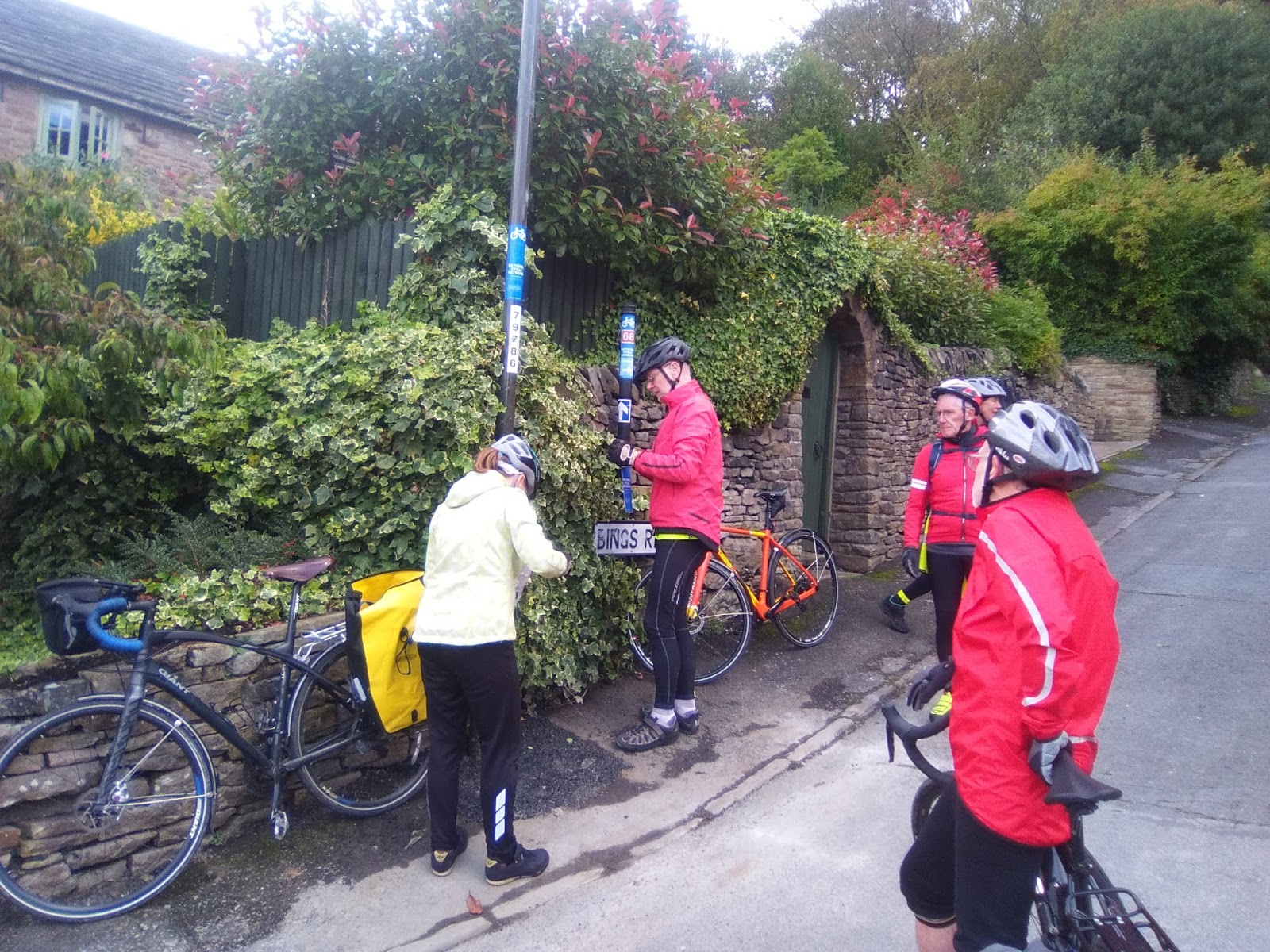
Minor signage issues were dealt with and old faded signs replaced. As efficient as ever, Catherine had cleaning materials to "spring clean" one or two of the route signs that looked as though they could do with one

Peter showed his ability as the new group photographer and the picture above clearly shows the value of Catherine's spring cleaning efforts.

NCR547 is a delightful route from Tissington across to the High Peak Trail via Bradbourne, Carsington and Hopton. Last year we had problems with vegetation on the short section between the B5035 leading down towards the STWA Visitor centre but we managed to arrange for SWTA rangers to undertake the major works required to clear it. The tyre marks through the mud suggest it is now well used, but some trimming back will be required again in the Autumn and so I will put onto our work plan.

The section a bit further down, literally just before the cycle track enters the STWA estate, has deteriorated as can be seen in the photo below. It certainly doesn't make the track unuseable, but care would be required if used by unconfident or vulnerable cyclists. I will try to see if we can get the STWA Rangers to help us repair it as some specialist input will be required to ensure the same problem doesn't occur as soon as we get the next rainstorm!


We coffee'd at the visitor centre (now a customary feature of work days) and then set off around the (very) full reservoir to leave the circuit track and head off into Carsington. This is a difficult junction and one that I know is concerning the Sustrans quality and safety guardians. We added a few more signs, just to make sure everyone knows where they are meant to be going.

Before we knew it we had reached the High Peak trail (NCR54) and it wasn't even lunchtime. Up on this exposed track it was pretty raw in the wind and so good speed made up the incline and on to Minninglow. (The temporary bridge at Grangemill is supposed to be replaced later this year, I read today. That will undoubtedly cause some disruption for cyclists and so we will need to keep an eye open for precisely when those works are due to take place?

From Minninglow David R suggested a cross-country route back to the Tissington trail via Parwich. I can't believe it but I don't think I have ever been to Parwich and Alsop en le Dale before. Both are delightful and the green in Parwich made a delightful (if not cold) place to eat our sandwiches. It was a great "short-cut" and David even had the solution for getting us safely across the A515 and back on to the trail. It did involve a short section of footpath but as we were pushing, not cycling I think we can be forgiven?

With the threatening rain clouds finally depositing their contents on us we enjoyed the slight downhill gradient along the trail, back to the cars in Tissington.

Another really useful day with plenty achieved.

Next workday will be on Friday April 3rd. Although David and Catherine keep that route in very good order it seems like quite  along time since we had a work day ride in that area. Therefore, that is where we will be heading!



Wednesday, 5 February 2020

February Work Day


The weather turned out to be much more clement than the forecasts had predicted. So, under bright blue skies and a watery winter sun we set about clearing the scrub, which was once again invading the edges of NCR 680 between Harrison Way in Darley Dale and the Rowsley sidings.

Ably directed by Groundwork's Marion Farrell, a small team of Sustrans rangers helped other members of the volunteer group with more lopping and pruning. It was also a chance for David and Catherine, Maldwyn, David (S) and myself to meet our newest volunteer Peter Posner for whom this was his first experience of  a ranger work (half) day.

Although this is only a relatively short section of national cycle route, ecologically it is a very important area for all sorts of wildlife. There is enough work here to fill at least 2 of our monthly work days each year (spring and autumn) but we may try to fit in an additional late summer session and flow it into a bbq social afterwards. Marion is keen to use an industrial mower to cut back the nettles and brambles which are now free of young saplings, but she needs volunteers to rake away the cuttings, once they have dried out. We now have a date for Friday 4 September, so that's another date for the diaries.

With the more formal part of the work day completed, a smaller group led by David and Catherine departed for a cycle ride through Chatsworth and then over to Hassop cycle hire from where they rejoined NCR 680. I understand the wind was pretty strong up the hill through Chatsworth and so by the time they reached the Hassop cafe they were ready for refreshments. The circuit was completed by cycling along the trail to the Coombs Rd viaduct and then trying the lane up past Coombs Farm and into Manners wood, before dropping down the (steep) hill, back into Rowsley. This lane has been made worse by logging vehicles a couple of years ago but, with care it is rideable. On a nice sunny day the route offers fabulous views over the Wye and Derwent vallies.

This section is due to be upgraded by Derbyshire CC shortly and will become a temporary alternative link between Rowsley and Coombs Rd. I am due to meet with DCC in a couple of weeks and will find out then just what the timescale is for the upgrade, and hence when we can plan for some signing of the temporary route (yellow stickers to the ready). 

Next work day is due to be Monday 9 March and I am suggesting we plan an activity around NCR 547 and the route through Carsington. More details to follow but please put into your diary if you are free. 


Wednesday, 22 January 2020

Derbyshire County Council - New county cycling infrastructure


I am delighted to provide you with links to the Derbyshire County Council website.

https://www.derbyshire.gov.uk/council/news-events/news-updates/news/cabinet-approve-proposals-for-new-cycle-routes-in-derbyshire.aspx

Late last week (and some 2 years overdue) they have finally produced a plan for improvement to the cycling infrastructure within Derbyshire.

"These plans show our ambition to cement Derbyshire as a world class cycling destination for everyone."

Before you all get too excited too quickly let's be a little cautious whilst we celebrate. I think that Clyde and I went to an event at Derby Velodrome when this project was kicked off in a blaze of publicity 3+ years ago. They refer to a recent 12 week consultation exercise before finalising the plan but I was certainly not aware of that from our attendance at the DCC External cycle users liaison group. I would have loved the opportunity to comment!

If we take the announcement at face value as an encoraging step in the right direction then there are some very interesting prospects for our ranger group in the Peak District.

The link above has links to a map and an executive summary  of the stages being considered . The ones that I thought to be of interest are summarised below.

Link # From To  Kms
17 Buxton r/way station Fairfield common 1.5 Medium term   3-5 years
16 Calton Lees Rowsley 2.7
19 Matlock R/way station Cromford (High Peak Junction) 7
18 Coombs Rd, Bakewell Rowsley 3.9
21 Ladmanlow, Buxton Macclesfield Rd, Buxton 1.7
22 Macclesfield Rd, Buxton Buxton r/way station 1.8
15 Baslow Calton lees 4.9

20 Harpur Hill, Buxton Ladmanlow (HSE land) 3.6 Long term > 5 years
17a Fairfield Common, Buxton Topley Pike 5.3
12 Castleton Bamford 6.5
68c Matlock Beeley Moor 8.4
68b Beeley Moor Holymoorside 5.9
68a Calton Lees Beeley Moor 4.3
23 Ashbourne Norbury/ Rocester 8.5
82b Longshaw Estate Dronfield 10.6
82 Derwent Valley Grindleford r/way station 2.7
82a Grindleford r/way station Longshaw estate 3.2

Note: there are VERY few sections in the strategy which carry a priority threshold of less than 3 years. None of these are within our region, so not included in this summary.

The top section of my summary are routes which can be prioritised to be delivered within 3 to 5 years. This includes outstanding sections of the White Peak loop. Interestingly it also includes a section through the Chatsworth estate from Rowsley to Baslow; something that I discussed with the Derwent Valley Cycleway team, Peak Park and Chatsworth Land Agent last Friday (please let me know if you would like more info ref those discussions). 3-5 years for some of these sections is probably not unreasonable on the BIG assumption that the Monsal Trail, or equivalent stays in place!

The bottom section of the summary above is even longer term; projects unlikely to be delivered within 5 years. Again, some very interesting suggestions here and ones that would certainly be very exciting if they were to happen.

Mentally I am visualising an incredible network of safe cycling into, through and beyond the Peak District. I am drooling at the prospect! We have a new goverment that has pledged, along with the opposition parties, to put money into cycling infrastructure. We have a new MP in Derbyshire Dales. I think we should start to put some pressure onto them to try and make some of this vision actually happen.

Happy to discuss further


Friday, 20 December 2019

Working with Peak Park Trails Rangers

I ventured out along the Tissington Trail today. I parked at Alsop en la Dale and headed south towards Ashbourne to meet up with Peak Park Trails rangers who I knew were working in the Mapleton car park area. It is a section of Peakland trail that I haven't cycled along for ages and despite the grey, heavy clouds it made me think again how lucky we are to live where we do with all of  this lovely countryside right on our doorstep. On the way down the trail was pretty much empty, except for the odd dog walker and I was able to use the gentle downward slope to travel along quite quickly. It was wet and amazingly quite busy on the way back!

Peak Park Authority now has two dedicated trails rangers who look after Tissington, High Peak, Monsal and Thornhill trails. The purpose of my visit to meet up with Dave and Emily was to see how we might be able to assist them with some track maintenance in 2020. Given our training with Marion Farrell and her Groundwork team I feel as though we have well and truly demonstrated our capability with bow saw and loppers.

It was very soon evident that significant trackside scrub clearing and tree cutting has been undertaken, especially south of the Tissington car park. Regular piles of thin tree boughs are dotted along the route to provide natural habitat that will encourage a greater diversity of fauna to live close to the trail. As I closed in on where the rangers had obviously been working the extent of their activity became even more colossal with much larger trees felled and large sections of trunk awaiting movement to firewood providers, I presume.

As Dave and Emily had been held up getting to the site I decided to go and treat myself to a coffee and cake at the wonderful "stickyfingers" cafe in Ashbourne. I enjoyed a coffee and lovely mince pie, even though I had hardly earned the latter. When I finally caught up with the rangers they told me;

The planned resurfacing of a large section of Tissington trail, north of Ashbourne is due to take place in February 2020 but due to a delay in getting a bridge certfified the whole job may now have to be deferred until February 2021.

The use of volunteers by Peak Park Authority is becoming more difficult without a lot of accompanying supervision. Dave and Emily are concerned that the limitations on their supervisory resource will prevent them from using a lot of high number volunteer groups. There will be some opportunities and he will certainly think about how he might be able to use the services that we are offering.

As an alternative, what they are looking to do is to appoint a smaller number of trails volunteers who will be formally recruited, undergo specific training and then induction sessions before they are let out to work in a much less supervised way, in pairs. Application for these posts is likely to start in March 2020.

Dave is happy to accede to our request for additional signage at Parsley Hay. He will let us have some dates in 2020 when he can be there to discuss the positioning of signage and planting of appropriate new posts (he will supply), if necessary.

The question of signing NCR 548 out of Hartington is not something that is of any concern to him, nor is the condition of NCR 548 from its start point to Dale end, Biggin. He is putting me in touch with the Ranger whose responsibility that trail is and I will take the matter up with them.

Dave is appreciative of our links with them (I think) but I am not sure that they will generate any great level of request for help from us, certainly not on a regular basis.

To note: the signage along the trail, together with signpositing to NCR 547 from Tissington all seemed perfectly adequate and in tact.

Friday, 6 December 2019

Route 680 - Temporary link section


You are all aware that I have been actively working with Derbyshire Disctrict Council over the last 18 months to try and find temporary alternative routes for the (2) missing links in the White Peak Loop.

It has proved difficult to identify suitable temporary alternative routes for missing sections of the White Peak Loop around Buxton which can be promoted for leisure and family cycling, due to the busy nature of some roads which are used by a considerable number of heavy goods vehicles. The missing section between Blackwell Mill/ Millers Dale and Buxton is therefore likely to remain "missing" for the forseeable future. The recruitment of a replacement DCC project manager has been stalled several times and whilst we came close in the summer to getting somebody in the post, the offer was withdrawn at the 11th hour. Without a project manager to lead the work necessary it is unlikely there will be any substantial progress. 

However, as a result of our regular discussions with DCC, funding has been secured to improve the condition of an existing bridleway which runs between Church Lane, Rowsley and Coombs Road, Bakewell as an interim measure to complete that as a temporary link. A scheme is currently being drawn up to carry out drainage work and surface repairs. It is certainly not an ideal option due to the severity of inclines at either end of the link. However, it is certainly better than having to use the A6 and it provides some absolutely fantastic views of the lower Wye and Derwent valleys. DCC are looking at the practicalities of a cycle crossing point on the A6 in Rowsley, next to the Peacock hotel. Hopefully in 2020 we will be able to sign the route officially as a temporary alternative part of NCR680.

Whilst that is all very good, positive news, the rumours are getting stronger about the reactivation of the Monsal trail as a working railway. All major political parties recognise the need to improve the rail infrastructure and this includes opening up abandoned rail lines, even if they are being put to very good use in alternative ways. Whilst the Peak Park Authority has pledged that any development could only take place if an equally suitable alternative to the Monsal Trail (NCR680) is found and developed, we might question whether even they have the strength and resilience to resist the onslaught of political and commercial pressures seeking compulsory purchase orders? If anything is likely to happen it is probable that we will see strong signs during 2020. Watch this space!

Supporting Groundwork with Track Maintenance


Once again there is a complete lack of photos to illustrate the full extent of our activities at last Monday's work day. My fault entirely, sorry for that failing!!

Anyway, a really enthusiastic bunch of White Peak Sustrans Rangers rather dominated the numbers of other regular volunteers of the Groundwork team, led by Marion Farrell. As well as David and Catherine the group also included David S, Brian and our latest recruit Jenni Ebbrell from Ashbourne (plus me). In addition we had two prospective recruits from Warslow and we hope to welcome John, Ian and possibly Doug too into our ranger numbers early in the New Year.

The weather was fantastic but after a heavy frost those tasked with removing leaves off the boardwalk section of track just south of Rowsley found that big clumps of wet vegetation were well and truly frozen to the planks. It was very hard work to get them off but by the end of the session much progress had been made and the cycle track pretty well clear of leaves. It is good to see that DCC has substantially replaced the broken planks, but how long it will be before others become damaged, we'll have to wait and see.

Individually, and in small groups, we worked closely with other members of the assembled team and found that a number of them also had a keen interest in cycling. John and Caroline from Cressbrook are particularly keen to think about becoming Sustrans rangers and so we were able to carry out some informal recruitment activity as we sawed and lopped our way along the verges of NCR680. This was a section of track  we have spent quite a lot of time working on earlier in the year but Marion certainly feels as though it has a lot of interesting wildlife and fauna habitats that she wants us to develop. It was wonderful to see so many people (cyclists and walkers) using the trail

Further sessions will be required in the New Year. Monday 3 February has been proposed.

Thanks to all for a pretty intense morning of quite heavy work, but the bright sun, blue skies and convivial spirit (not to mention double helping of chocolate biscuits) all made it into a very enjoyable experience.

David and Catherine did go onto look again at the possibility of an alternative route at the start of NCR548 near Hartington. Unfortunately it is too complex a problem for a ready solution and so we will defer that task until next year. Thanks to them both for diverting round to look at the issue.

Friday, 18 October 2019

Venturing into pastures new - October work day


ON another beautifully sunny "work" day we ventured onto part of the Sustrans network that we all know least well; a stretch of route 68 leading north out of Buxton up towards Whaley Bridge and Chapel en le Frith.


The White Peak Ranger group has responsibility for the section of route 68, which leads out of Buxton along the main Manchester Road for a couple of kilometres, before it veers away from the A5004 on a much quieter road towards Combs Moss. At this point our group hands-over responsibility for the route to Joan Bennet who looks after the next section single handedly.

Myself, the Rookes, David Sharpe and Brian Raine met up with our newest recruit Naomi McFadyen at Buxton station full of enthusiasm for a ride into parts of the Sustrans network that we are all quite unfamiliar with. Or were we? It was most gratifying to see that the extra signs we put in place earlier in the year to link the station concourse on to route 68 were still all in place. We still think that they should help people get to/ from the station from route 68 quit ereadily and so we made no further adjustments. I wonder how many people have used them and thought how helpful they are?

With no more ado we set off up the hill out of Buxton keeping well into the kerb for safety from the traffic using the same road. This is not the best section of cycle route in the country. There is no cycle track marked on the road and although the flow of traffic was not really heavy it is a slow climb out of the town through a built up area. We did wonder whether there may be some back roads behind the station which might make the exit/ approach from the station more pleasant, but decided to leave that matter for another day.

We added a few more signs to lamposts as confirmation to users of the route that they were still travelling in the correct direction. Otherwise the signage put in place about 3 years ago all seemed to be fine and only needed replacing where the sun and rain had weathered the existing signs so badly they could hardly be seen.

The point at which our responsibilities are handed over to Joan is on a dangerous bend in the A5004, but it is well signed and I guess there is a verge that cyclists can pull onto if traffic is exceptionally heavy. Unfortunately Joan was unable to ride with us on this day but she had said she was happy for us to check the route up to Whaley Bridge, if we had time.

This little lane that we now found ourselves on was new territory for me, but it was still heading north in an upwardly direction. After a short while the tarmac comes to a very sudden end and, as on our September ride, we once again found ourselves on a very rough track that many Sustrans users would find difficult to cycle on. Maybe we can try to find somebody who can "sponsor" a few lorry loads of gravel that would improve the surface enormously? Having survived the worst of it the track it levelled off a bit before deteriorating alarmingly once again to bring us down the side of the hill behind the White Hall centre. There are no alternatives for this "rough" section but maybe we need to go back and put some "rough track" stickers at either end?

Whilst these poor surface sections take a while to navigate safely they are not especially long in length. Once past them the route returns to a tarmac surface along the delightful Old Road and Long Lane before a steep drop down into Whaley Bridge. Once again, only minimal work necessary to the existing signage.

It was only as we came into the town that Naomi let on that she had lived in Whaley Bridge for many years and knew it really well. Just below where she used to live we had a major discussion about the  need for siting of additional signs where the route takes a sharp deviation away from the town. It was only when David (S) located a "stray" drainwater pipe and returned it to its correct position that it all became clear as to what was required!

With Naomi's inside knowledge we enjoyed a cup of tea in a lovely cafe (thank you David) before settling to our sandwiches overlooking the canal basin. Although the sun was shining it was very autumnal sitting by the water and we all foolishly said that what we needed to warm us up was a hill!. Well , we certainly had them on the return route back to Buxton via the lovely Fernilee reservoir. We had two really monster hills, both of which went on for what seemed like endless mile after mile. Brian of course coped with them very comfortably on his e-bike. The rest of us took them more slowly. Despite the hills this made a wonderful circuit and left us with just a downhill ride along the A5004 back to our starting point at the station.

Well done everyone, another really useful day of route checking in an area that is at the extremity of our region.


The final drag to the top of the monster hill! Thanks for reminding us Naomi.