The blog of the Sustrans Volunteer Rangers in the White Peak. Our area contains traffic-free cycling and walking trails, including the High Peak Trail, the Tissington Trail, the Manifold Track and the Monsal Trail, as well as various on-road cycle routes belonging to the National Cycle Network, in particular Ashbourne to Etwall. We ride these routes regularly, notifying Peak Park or Derbyshire and Staffordshire county councils of any problems. We also sign the trails which are parts of the NCN.
Friday, 18 October 2019
Venturing into pastures new - October work day
ON another beautifully sunny "work" day we ventured onto part of the Sustrans network that we all know least well; a stretch of route 68 leading north out of Buxton up towards Whaley Bridge and Chapel en le Frith.
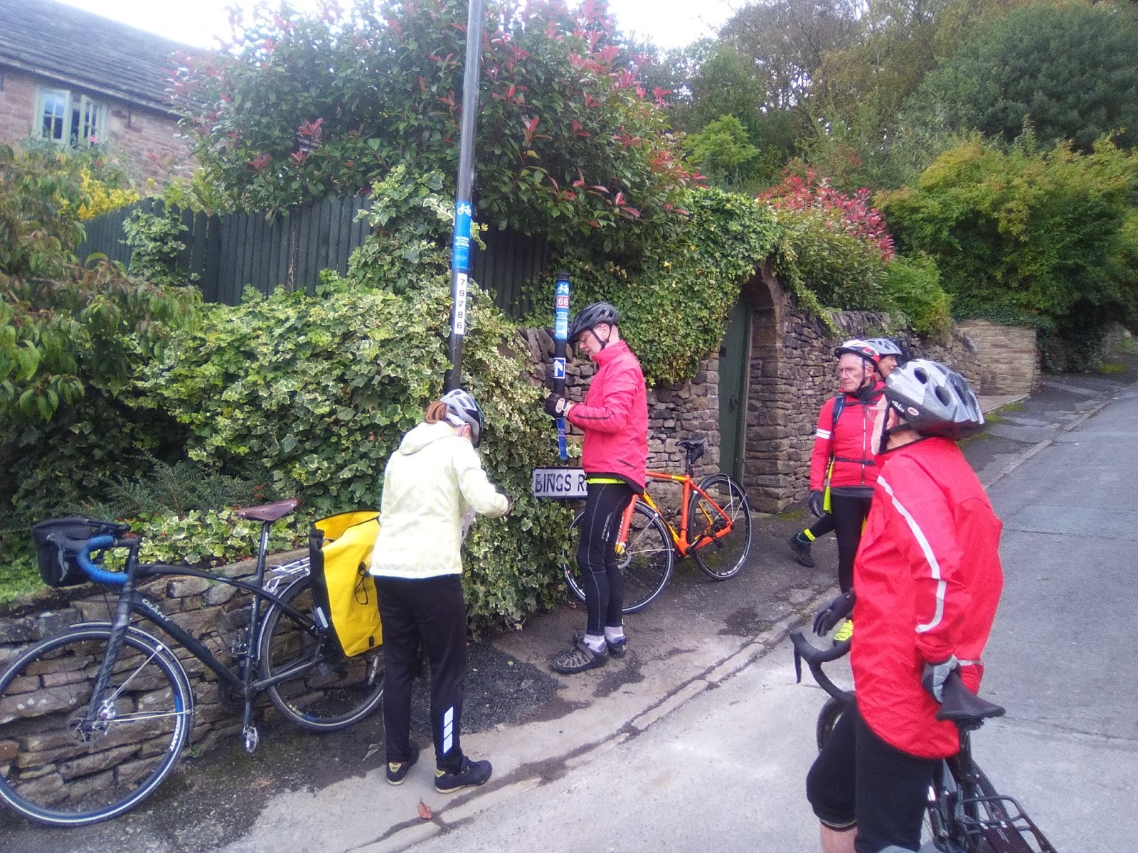
The White Peak Ranger group has responsibility for the section of route 68, which leads out of Buxton along the main Manchester Road for a couple of kilometres, before it veers away from the A5004 on a much quieter road towards Combs Moss. At this point our group hands-over responsibility for the route to Joan Bennet who looks after the next section single handedly.
Myself, the Rookes, David Sharpe and Brian Raine met up with our newest recruit Naomi McFadyen at Buxton station full of enthusiasm for a ride into parts of the Sustrans network that we are all quite unfamiliar with. Or were we? It was most gratifying to see that the extra signs we put in place earlier in the year to link the station concourse on to route 68 were still all in place. We still think that they should help people get to/ from the station from route 68 quit ereadily and so we made no further adjustments. I wonder how many people have used them and thought how helpful they are?
With no more ado we set off up the hill out of Buxton keeping well into the kerb for safety from the traffic using the same road. This is not the best section of cycle route in the country. There is no cycle track marked on the road and although the flow of traffic was not really heavy it is a slow climb out of the town through a built up area. We did wonder whether there may be some back roads behind the station which might make the exit/ approach from the station more pleasant, but decided to leave that matter for another day.
We added a few more signs to lamposts as confirmation to users of the route that they were still travelling in the correct direction. Otherwise the signage put in place about 3 years ago all seemed to be fine and only needed replacing where the sun and rain had weathered the existing signs so badly they could hardly be seen.
The point at which our responsibilities are handed over to Joan is on a dangerous bend in the A5004, but it is well signed and I guess there is a verge that cyclists can pull onto if traffic is exceptionally heavy. Unfortunately Joan was unable to ride with us on this day but she had said she was happy for us to check the route up to Whaley Bridge, if we had time.
This little lane that we now found ourselves on was new territory for me, but it was still heading north in an upwardly direction. After a short while the tarmac comes to a very sudden end and, as on our September ride, we once again found ourselves on a very rough track that many Sustrans users would find difficult to cycle on. Maybe we can try to find somebody who can "sponsor" a few lorry loads of gravel that would improve the surface enormously? Having survived the worst of it the track it levelled off a bit before deteriorating alarmingly once again to bring us down the side of the hill behind the White Hall centre. There are no alternatives for this "rough" section but maybe we need to go back and put some "rough track" stickers at either end?
Whilst these poor surface sections take a while to navigate safely they are not especially long in length. Once past them the route returns to a tarmac surface along the delightful Old Road and Long Lane before a steep drop down into Whaley Bridge. Once again, only minimal work necessary to the existing signage.
It was only as we came into the town that Naomi let on that she had lived in Whaley Bridge for many years and knew it really well. Just below where she used to live we had a major discussion about the need for siting of additional signs where the route takes a sharp deviation away from the town. It was only when David (S) located a "stray" drainwater pipe and returned it to its correct position that it all became clear as to what was required!
With Naomi's inside knowledge we enjoyed a cup of tea in a lovely cafe (thank you David) before settling to our sandwiches overlooking the canal basin. Although the sun was shining it was very autumnal sitting by the water and we all foolishly said that what we needed to warm us up was a hill!. Well , we certainly had them on the return route back to Buxton via the lovely Fernilee reservoir. We had two really monster hills, both of which went on for what seemed like endless mile after mile. Brian of course coped with them very comfortably on his e-bike. The rest of us took them more slowly. Despite the hills this made a wonderful circuit and left us with just a downhill ride along the A5004 back to our starting point at the station.
Well done everyone, another really useful day of route checking in an area that is at the extremity of our region.
The final drag to the top of the monster hill! Thanks for reminding us Naomi.
Friday, 13 September 2019
September work day
Not a single picture taken during this work day! How remiss!
However, the lack of photographic evidence certainly does not detract from what we achieved. We started at Hartington and then used routes 548, 68 and 549 to complete a lovely loop through parts of the White Peak area and Dovedale. Although much of our circuit was on routes we have checked for quality and signage within the last 12 months, it was amazing just how much we found to deal with.
David (R), Catherine, David (S), myself and Brian Raine (our newest recruit) set off up the hill out of Hartington to join the start of NCR 548 (DCC are going to consider a new sign in Hartington directing riders towards 548). Brian was able to set a strong pace on his very fine looking electric bike, but was slowed down when we turned onto 548 itself. The quality of this track has deteriorated considerably due to the heavy rains, which have created some deep gullies and a lot of loose stone. I have reported the condition to both DCC (adopted highway) and Peak Rangers but not sure how highly either will prioritise it. We are also looking at the possibility of offering an alternative on-road alternative with Tom (I have requested signage from Alexa). The descent into Dale End is just as bad and caused bodily damage to one of our group!
The difficult start to the day required strong leadership and so we promptly adjourned to the delights of Biggin Hall for a very welcome coffee break. This sort of decadence is not part of our usual itinerary, but I think it could easily become so.
Refreshed by coffe and a cleaning of cycling wounds we raced on up to, and along NCR 68 to Parsley Hay. An obvious lack of signage here was clearly overlooked when we visited last year but Dave Watts (Peak Park ranger) has agreed to help make some provision to remedy the position.
Then onto Hurdlow where we reviewed the signage indicating alternative routes. This has become very faded and in need of replacement. I have subsequently requested new signage from Alexa using a form of words that will hopefully inform riders about why there are alternative routes at this point (rough track at end of High Peak Trail). A few additional signs at the end of the High Peak trail have hopefully clarified where route 68 goes to and we then returned to Hurdlow using the alternative, on-road section.
By now the effect of coffee was wearing out and lunch was well overdue. Some of the team had read the work day instructions carefully and bought sandwiches with them, as requested. I had to adjourn to the nearby Royal Oak for a rather expensive take-away which I was then able to enjoy with the others at a nearby picnic spot.
Suitably refreshed, if not somewhat chilled we cycled to the start of NCR549 and followed this lovely road all the way down to Pilsbury and then along side the river Dove in the valley bottom. It is such a delightful route back into Hartington.
Brian left us at this point but the rest of us retraced our earlier route back up the hill, but only as far as the turn off onto NCR 549, which we then followed down into Beresford Dale without incident. David and Catherine have previously reported repeated acts of sign vandalism in this area and so we were delighted to find that all of the signs they had replaced recently were still in tact. I have reported to Peak Park the possibility of confusion for walkers who follow cycling signs for Hartington at this point.
So, David and CAtherine split off at Hulme End to ride home, whilst David (S) and I cycled along the main (but quiet) road back into Hartinton and thereby end another very productive day. Thanks to all.
Sunday, 14 July 2019
New link finally created in the Hope Valley
Our latest work day saw a small number of the group out in the Hope Valley with a very full work load for the day. We last visited NCR 6 in May 2018 and although we did a lot of re-signing on that day there was still much to do on this visit. David & Catherine and myself parked up at Hope Station and immediately started to put up new signage to direct cyclists from the station towards NCR6.
Last year we did not cycle from Hope to Castletong along NCR6 and so quite a lot of sign replacement had to be undertaken where the old signs had become very faded. Part of the day's tasks was also to address issues identified on the Earthlight map as a result of Sustran's recent route audit check. The section from Hope to Castleton had aparticularly high incidence of issues and it took us quite a long time to identify the point on the ground where improvements had to be made. Eventually we got to the current end point of NCR6, which is in the centre of Castleton itself and we duly put up a red sign advising that no further signing beyond this point was available. One day they will perhaps complete a route over Wynatts and link up with NCR6 on the other side of the Pennines where it already starts its onward journey up to the Lake District.
With our stocks of basic directional signs, as well as red NCR 6 stickers much depleted we headed back to Hope and the point at which the route turns up towards Aston. More stoppages for audit issues but eventually we arrived at Thornhill and the junction with teh Thornhill Trail. This has been a particularly difficult place to sign as somebody keeps removing or defacing signage we have put there previously. Some of the signs (but thankfully not all) we put at this point last year have been removed and had to be replaced. We also added extra signs showing onward distances from this point, as well as new signs offering cyclists the opportunity to use teh Thornhill Trail to access Bamford station (more of which later).
When we ran out of straight arrows Catherine had to get out her scissors and show some of her creative talents!
We found a lovely picnic spot overlooking Ladybower reservoir and ate our sandwiches as we rested after a fairly full-on morning of activity. After lunch we found that more work with signage was required that we had expected in terms of getting cyclists up to and off the track across the dam wall. We will need to monitor this signage closely as I am sure we ensured it was all in place last year.
Having sorted out the dam wall we returned to the head of teh Thornhill Trail and were relieved to find that signage placed there before lunch was still there. The signage removers are not as efficient as us!
In May 2018 we started our efforts to get all the necessary permissions to use teh Thornhill Trail and Water LAne, BAmford to create a permitted link to Bamford station. It has taken us over a year to get the permissions (Peak Park, Quakers, Local businesses, DCC and Parish Council) and special signage. Armed with signs we cycled along the lovely wooded trail (old railway line used for constructing the dam) until we reached Water Lane at the bottom. I have agreed with the Quakers that we will erect special signs at the start and end of their property to advise cyclists that it is a permitted right of way and to take care. However, at the start of the lane we really struggled to find anything to attach the sign to. It was as much as we could do to affix directional signs onto a very rotten fingerpost, but for the time being at least there is some indication that there is an approved link to the station. At the road end things were only marginally better, and we were left with little choice other than to fix our special sign to a handily placed telegraph pole.
Finding street furniture along the road to which we could affix further signs was also difficult and whilst we did the best we could with what is available it is far from perfect.
Things just weren't going our way. The supply of directional arrows had long since been depleted, but Catherine was robotic in her ability to create temporary stickers from other signs we were able to cut up. We ran out of other adhesive stickers and had some tough decisions to make about where we should position the last one that either of us had. In the end we decide to put it high on a lampost in the hope that cyclists arriving at Bamford from the Sheffield direction woul dbe able to see it. We'll nee dto go back once we have refreshed our stocks of signs
So, all in all a busy, but very productive day with a bit of frustration thrown into the mix too. At least the link is now in formal existence after such a long time of trying to get it to be areality. I wonder who'll benefit from it??
Friday, 21 June 2019
A wet day checking NCR 54
Despite
the inclement weather a useful day was had - cleaning old signs, replacing
manky ones and removing foliage where needed.
After meeting up with David
Sharpe and new recruit Naomi Mcfadyen we (David and Catherine) set off from Minninglow car park on
route 54 towards Wirksworth. We noted the temporary bridge at Longcliffe was
very satisfactory. Some work was needed at the junction of the 54 and 547 where
a sign needed turning, having presumably been knocked by a lorry. We didn’t have
any 547 signs with us so were unable to replace some that are needed but we
will order some more asap and return to finish the job.
Two drowned rats but no
cyclists were spotted on the road at Carsington. A nasty tack was found in
Naomi’s back tyre, which was mended with panache in the ‘doubly thankful’
village of Bradbourne.
We had a downpour as we cycled back up the hill from Parwich to Minninglow but it failed to dampen our spirits.
Monday, 20 May 2019
Southern extremities
Today we visited the most southerly extremities of the White Peak Rangers' area. We travelled from Ashbourne to the outskirts of Etwall along NCR 68 where it meets routes NCR 54 and 549.
Our monthly work day started differently as we met in one of Ashbourne's delightful deli and cafe bars for an update from Tom on Sustran's new Earthlight mapping software. The purpose was to get us involved with looking at how the recent independent audit of National Cycle Route had assessed routes within our region. Whilst some other regions seem to be covered by a forest of "blue crosses" to indicate signage issues, ours seems to be only sparsely covered. A great credit to the work done by White Peak rangers in the past. We will need to see precisely what issues were picked up by the auditors, as long as two years ago and ensure that we update the notes with the latest position. We have up to two years to do this, by which time Network Development Plans have to be drawn up and put in place. Tom helped us to understand all the reviews and projects that are taking place presently, although talk of de-activation of 5% of routes and activation of other new projects all made us wonder what the network in our region might look like in 5 years time??
Regional News earlier on in the day had spoken about funding available for the Derwent Valley cycle path and Tom confirmed that this was specifically mentioned in a recent award of £21m to Sustrans for infrastructure improvements.
Updated with information about the software and plans for how we would use it we set off on bikes in broken sunshine to travel out of Ashbourne and south to Etwall. Escaping out of the town was excellently navigated by Catherine, despite having to cycle along the very busy A517. We soon left the traffic and headed up the hill through new housing estates before hitting the very empty country roads of south Derbyshire. This is a very different landscape to the one in the north of our region but certainly one that is ideal for easier, safe cycling.
Passing through Wyaston, Rodsley and Longford we enjoyed the very rural, pastoral landscapes but these feel like very dormitory villages with active life all but totally sucked out of them. The pub in Wyaston was closed today, and so it was lucky we had taken sandwiches for a picnic with us. The cafe in the Tara Buddist Centre would have made an interesting deviation had we listened to Catherine's cries suggesting a detour.
Refreshed by our sandwiches, enjoyed all the more by eating them in the middle of a field under sunny skies, we agreed we could complete the rest of the route to Etwall today, after all. Stops to replace faded NCR 68 signs were few and far between but nonetheless we have certainly left the whole route looking a lot smarter than it was first thing this morning.
Having reached the intersection of routes 54, 549 and 68 just north of Etwall we celebrated having reached the southernmost extremity of our region before turning around and heading back exactly the same way. A most enjoyable day thanks to David & Catherine, Andrew and David S. Thanks to Tom also for coming out and giving us the talk first thing.
Monday, 8 April 2019
Work Day - Route 548
As the pictures below confirm, our April work day was a pleasure to undertake as we were cycling in the White Peak with glorious sunshine and lovely blue skies. Route 548 runs from Hartington to an intersection with Route 54 on the High Peak trail, close to Minninglow hill fort. Significant sections are on gravel surface but should be reasonably safe for most riders to cope with. The views out across the White Peak area are unforgettable and breath taking along this route.
The iconic view of Minninglow hill fort in the distance. It is accessible from NCR 54 by means of a concessionary footpath. Something I really must do one day as I have never been up it. 

The roughest section of track but nonetheless our cross-section of bikes all coped with it very adequately. Clyde on his new Brompton survived, although I think it was a bit touch and go on the steepest of the sections. The signage along the route has been in place for many years now and so we had to replace quite a lot of it. Certainly more than I had expected would be necessary
We also took the opportunity to put a number of new signs into place, both on NCR548 and the High Peak Trail (NCR 54). I think we can all feel very pleased and proud of what we have achieved today. This part of the National Cycle Network is certainly of a higher "signed" quality after our work day today. All the more so because Clyde (who else) found a stash of (54) and (548) stickers that enabled us to link NCRs 54 and 548 with each other using additional green ways. Well done Clyde - we really have missed you.
Many thanks to all who contributed - David & Catherine, Clyde, Maldwyn, Tom and our newest recruit David S (Sharpe)
Friday, 1 March 2019
Carsington Water - update on track condition
In response to an email received from a user of NCR 547, close to Carsington Water we used one of our recent work days to go up and have a look at the condition of the track from where it starts on the B5035 down to where it links into the drive into the Carsington Water Visitor Centre.
Andrew and Maldwyn confirmed that the initial part of the track (behind the Pudding Pie cafe) was very overgrown and unlikely to be used by cyclists in its current state.
They reported that the scale of the problem was such that it would take our small group several work days, even with a good turn out to resolve the problem. I tried to ascertain who has ownership of the land and in that process formed a useful liaison link with Severn Trent's Carsington Water Ranger Group. Without too much persuading they volunteered to apply their own full time and volunteer ranger groups to help sort out the problem for us. John and Chris have been excellent and we are truly indebted to them for the work they have done.
The picture below shows the state of the track a bit further down the hill before they started to clear it.
And this is it now! Having been up to look at the transformation this morning I am delighted to see plenty of fresh bike tyre marks along the track, which is now visible. Andrew suggested there be a sign at the B5035 indicating it is 3/4 mile from there to the visitor centre. I have ordered that and as soon as I have it I will go and affix it so as to complete our maintenance of that section at least.

Sadly, more maintenance work is required further down the track. Water is running down the centre to form a gully, as shown by the pictures below. I don't think it is critical to repair this immediately as it is certainly still rideable for all but the most timid of riders. However, I think we need to add it to our list of work for monthly work days. Is it beyond our experience and capability? I think we will need to build in some drainage baffles to divert water off the track at regular intervals, as well as putting down a lot more stone. I will try and get Seven Trent Rangers to help us complete that work.
For now though, this important section of NCR 547 is back to a reasonable standard and fully functional
Subscribe to:
Posts (Atom)


